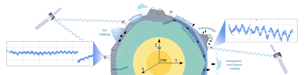
Global Navigation Satellite Systems (GNSS) are a cornerstone of modern Earth observation. Continuous GNSS networks provide multi-decadal displacement time series with millimeter-level precision, enabling the study of tectonic deformation, glacial isostatic adjustment, geophysical loading, anthropogenic groundwater depletion, volcanic and seismic transients, and long-term vertical land motion relevant to sea-level rise and climate research. Beyond these direct applications, GNSS also provides the terrestrial reference frames and precise satellite orbit determination required for the consistency and long-term stability of many satellite-based remote-sensing climate data records, thereby forming a key element of geodetic and Earth-observation infrastructure.
This dual role — as both enabling infrastructure and observing system — places exceptional demands on the interpretability and stability of GNSS time series. Many of the deformation signals now targeted by the community are subtle, long-term, and close to the limits of what GNSS can reliably resolve. Trend magnitudes of only a few tenths of a millimeter per year, low-amplitude transients, and slowly evolving seasonal or interannual variability are often comparable to residual systematic effects arising from processing strategies, reference frame realizations, background models, monument stability, or unmodeled environmental influences.
As a result, different analysis centers, processing approaches, and geophysical modeling choices can yield divergent interpretations of nominally similar GNSS observations. For example, this is particularly evident for vertical land motion and other low-frequency signals, where discrepancies between GNSS solutions — or between GNSS and independent observations such as InSAR or GRACE/GRACE-FO — are no longer negligible relative to the geophysical signals of interest. Related challenges also arise at shorter time scales when separating atmospheric effects, geophysical loading, and noise in daily or sub-daily GNSS data.
Why this Forum, and why now?
GNSS is increasingly used beyond traditional geodesy, including in hydrology, glaciology, sea-level science, climate monitoring, and natural hazard assessment. At the same time, multi-constellation GNSS and evolving processing strategies introduce new long-term systematic effects, while uncertainty quantification and stability assessment frameworks often lag behind scientific ambition. Independent Earth-observation datasets now provide unprecedented opportunities for cross-validation, but also expose inconsistencies that require careful interpretation.
Objectives
The GNSS Forum aims to provide a structured space to:
- critically assess current limitations in GNSS time-series analysis;
- clarify the roles of processing choices, reference frames, background models, and stochastic assumptions;
- discuss realistic strategies for uncertainty and stability assessment;
- explore pathways forward through improved processing, modeling, and validation;
- translate GNSS expertise into robust products for Earth-system and climate applications.
Role of Participants
Participants are invited as experts with complementary perspectives across GNSS processing, reference frame realization, and scientific applications. Complementary perspectives are very welcome as inputs to synthesis, grounded in data, theory, and well-defined methodological experience.
Expected Outcomes
The outcomes will be summarised in one or more peer-reviewed publications and/or a community white paper, strengthening GNSS as a foundational observing system for measuring the changing Earth and enhancing its integration with complementary Earth-observation approaches and Essential Climate Variables.